
Records
Your search returned 404 Results
Refined by : Special Collections Geolocation
- Iconographic browsing
- Results per page : 50
-
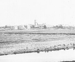
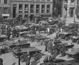 A Busy Market Square, Copenhagen
A Busy Market Square, Copenhagen
The scene before you gives some notion of the reason for the name of the capital city of Denmark. The word "Copenhagen" (k´pn-h´gn) means "merchants' harbor." And here are buyers and sellers a-plenty in this busy old city. Can you make out what is for sale? Copenhagen is an ancient, island city. A thousand years ago a fishing village stood where the present city now is. The village grew because the harbor is one of the finest on the Baltic Sea. Besides, it is at the western end of the Baltic, and receives ships going into and out of this northern ocean. In time the king of the Danes made it the capital of his country. Now it is a city larger than San Francisco. It is built on two islands separated by a stretch of water called the Haven, where the shipping lies. Here are ships flying the flags of all nations. And here too, are large shipbuilding ways where the vessels are being constructed. The Dames have always been a seafaring people. They invaded England; and Iceland and Greenland are still their colonies. In addition to its commerce, the city is noted for its porcelain works, breweries, sugar refineries, and cloth factories. Much of its trade is carried on with Norway, Sweden, Germany, and Great Britain. The city was once the home of a famous sculptor named Thorwaldsen. One other Dame you probably know about. He is Hans Christian Andersen, the author of fairy tales. The soil of this little land is poor and the climate is severe in winter. Dairying, poultry raising, and sugar beet farming are the chief occupations in the country. Keystone ID: 13082 Note: All titles, descriptions, and location coordinates are from the original Keystone Slide documentation as supplied by the Keystone View Company. No text has been edited or changed. -
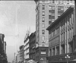 A Busy Street in Minneapolis, Minn.
A Busy Street in Minneapolis, Minn.
Minneapolis sprang up at the Falls of St. Anthony on the Mississippi. Not many years ago Minnesota was noted for its lumbering. The Falls of St. Anthony furnished power to drive the machinery of great sawmills and planing factories. When the lumbering ceased to be so important, agriculture took its place. In a few years there were miles of wheat fields on the prairies, particularly in the valley of the Red River of the North. Today Minneapolis is the greatest flour making center in the world. North Dakota, South Dakota, and Minnesota grow a great deal of flax. This is raised for its oil. Minneapolis is the center of this trade, so it has great linseed oil factories. Linseed oil is made from flax seed. It is used to mix with paint. The seeds are crushed, the oil is pressed out, and the seedcakes are fed to farm animals. Minneapolis and St. Paul are so near each other they are called "The Twin Cities." Together they are the greatest railroad center northwest of Chicago. Minneapolis has 4 transcontinental railway lines and 9 railway systems Seven lines connect it with Chicago, 6 of which end in Minneapolis. The city has broad, clean, well-lighted streets. Nicollet Avenue, shown in the view, is the chief retail thorough fare and one of the finest streets in the city. Minneapolis has a fine park system, containing nearly 4,000 acres. In one of these parks is Minnehaha Falls, which you have read about in Longfellow's Hiawatha. The state university is also in Minneapolis. It is one of the largest universities in our country. Minneapolis is the largest city in Minnesota. It has a population of over 300,000. Which way is it from Chicago Keystone ID: 16703 Note: All titles, descriptions, and location coordinates are from the original Keystone Slide documentation as supplied by the Keystone View Company. No text has been edited or changed. -
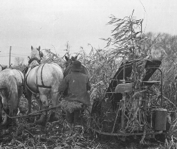 A Corn Harvester at Work in Indiana
A Corn Harvester at Work in Indiana
Corn is a double food supply for stock. The grain is one of the best foods known for horses, cattle, sheep, and hogs. And the stalks and leaves when cured take the place of hay and straw both as food and bedding. On many, perhaps most, small farms, corn is cut by hand. When it begins to ripen in September men cut it several inches above the ground and set in shocks. It is then spoken of as corn fodder. On damp days during the fall or winter the shocks are torn apart, and the corn is husked. The fodder is reshocked, and is hauled out of the field as it is needed for food. But corn cutting by hand is slow and hard work. It takes a strong, quick field hand to cut 30 shocks, 12 hills square, in a day. Hence, a machine was invented to cut corn more rapidly and with less labor. You see here one of these corn harvesters at work. The machine is built to cut but one row at a time. The corn is caught between two slanting uprights and a sickle cuts it off. It is tied in bundles at the same time, and these bundles fall from the rear of the harvester. All the workman needs to do is to drive his team properly. The bundles may be hauled to barns or silos for storage or they may be set in shocks, in much the same way wheat is handled. This machine does not husk the ears. The first of these harvesters that were operated did not meet with favor. They knocked off too many ears of corn. This objection has been partially overcome. At any rate it is no great task to pick up the fallen ears in field where the corn has been so harvested. And there is a great saving in labor and in time by using machinery instead of men. Keystone ID: 16712 Note: All titles, descriptions, and location coordinates are from the original Keystone Slide documentation as supplied by the Keystone View Company. No text has been edited or changed. -
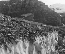 A Crevasse in the Victoria Glacier, British Columbia
A Crevasse in the Victoria Glacier, British Columbia
On the Canadian Pacific Railway, about 100 miles west of Calgary, is the Rocky Mountain Park of Canada. This is a reservation (rz´ r-v´ shn) of the Dominion Government. It contains about 5,000 square miles. It is sometimes called the Canadian Yosemite. It has many mountains from 8,000 to 10,000 feet in height, a number of hot springs, and one of the most beautiful lakes in the world, Lake Louise. Within its limits are many wild animals such as deer, caribou, (kr´ -b), bears, elks, wild goats, and long-horned sheep. The reservation includes some of the finest glaciers in North America. Here you are on one of these great ice sheets on the side of Mt. Victoria. In the background you see the peaks of Mt. Lefroy and Mt. Victoria. Directly in front of you is wide crevasse (kr-vås´) with sheer sides of solid ice. You see the snow crystals glistening in the bright sunshine. A misstep here would send you into the bottom of the deep, ice-bound precipice. When mountain climbers come to a crevasse such as this, and can find no way around it, a ladder must be constructed to make the crossing. If the chasm (kz'm) is narrow enough for the guide to leap it, a rope ladder can be made to bring the party safely over. Mt. Victoria is a peak 11,400 feet high. It takes skillful mountain climbers from 7 to 9 hours to make the ascent. It was first climbed in 1897. It is a dangerous climb because of the snow and because of the crumbling, overhanging rocks on some of the paths. Mt. Lefroy is 11,290 feet high. It is more difficult to climb than Mt. Victoria. One of its passes over which the ascent is made is called the Abbot Pass, after a mountain climber who there lost his life. Keystone ID: 13830 Note: All titles, descriptions, and location coordinates are from the original Keystone Slide documentation as supplied by the Keystone View Company. No text has been edited or changed. -
 A Fishing Village, Netherlands
A Fishing Village, Netherlands
Open your geographies to the map of Netherlands. You see that the sea has bitten out of the center of it a great mouthful of land. This stretch of water is called Zuider Zee. "Zee" in Dutch means "sea.." Ages ago the sea covered a large part of the land we now call Netherlands. Then the waters lowered. Sand dunes were piles up with great arms of the ocean running far into the land. But the rivers brought down soil and filed up the channels. Then the Dutch came, and they set to work to help Nature out. They built dikes like the sand dunes, and pumped water back into the ocean. Thousands of acres in Netherlands have thus been captured from the sea. The work is still going on. The Zuider Zee is being drained and filled in from year to year. Some day the Zuider Zee may not be on the map of Holland. You are looking at one of the flat islands of this inland sea. It looks to be scarcely above the water's edge. Not a tree in sight. The houses of the little fishing village are huddled together as if they were afraid. The people, at least, have one great fear hanging over them. This is that the sea may rush in during a storm and flood their land. But the fishermen are bold. To the northwest is one of the greatest fishing grounds in the world. Here the Dutch trawlers go for their catch. They are manned by hardy sailors as bold as Hendrik Hudson. Perhaps the Dutch have fought the sea so long they are naturally its masters. At any rate their vessels have explored all parts of the world. Dutch colonies are in both Americas and in the far-away East Indies. The Dutch East India Company has played as important a part in the history of commerce as that of the Hudson Bay Company of the English. What did Hudson discover? Keystone ID: 6436 Note: All titles, descriptions, and location coordinates are from the original Keystone Slide documentation as supplied by the Keystone View Company. No text has been edited or changed. -
 A French Winter Resort, Cannes
A French Winter Resort, Cannes
You may be unable to find the city of Cannes (kån) on your map. It has a population of only 35,000, yet it is widely known in Europe. It is famed as a winter resort. It lies on the gulf of the Mediterranean, northeast of Marseilles (mär-slz´) and southwest of Nice (ns). The coast here is called the Riviera (r-vyâ´ rä). The Riviera runs from Cannes to Genoa. The Alps close in on the west and the Appenines of the east. Here during the winter months come hundreds of persons to escape to cold of Paris, London, or Berlin. The climate of this section is semitropical and very healthy. The slope is southerly, and the warm winds from northern Africa make it pleasant in midwinter. People of Europe go to Cannes in the winter just as people of the northern United States go to Palm Beach or Los Angeles. The city has many fine villas with beautiful gardens about. Most of these houses are built of white marble quarried from the nearby hills. Cannes is a city of flowers. On the hill slopes back of it some 60,000 acres are set to flowers from which perfume is made. There are orchards of fig trees, olives, peaches, oranges, almonds, and lemons. The gardens about the houses are bright with flowers and the blossoms of semi-tropical trees. The harbor is small and is used chiefly by private yachts (yôt), sailboats, and launches. Some of these you can see here. Boating and bathing are the popular pastimes of the wealthy. Nearby are many beautiful islands that make excellent picnicking grounds. There are a few historic spots in Cannes that are worthy of note. One of these is an old church 600 years old. There are also the ruins of a castle, and a tower. From the tower one can have a fine view of the city and the harbor. Keystone ID: 11760 Note: All titles, descriptions, and location coordinates are from the original Keystone Slide documentation as supplied by the Keystone View Company. No text has been edited or changed. -
 A Highland Home, Scotland
A Highland Home, Scotland
You have here a view of a peasant's house. Such houses can be found throughout the length and breadth of Scotland. Most of them are built in the same way. That is, their walls are made of stones or bricks, and their roofs of thatch. Simple as they are, though, they are very pleasing to the eye. In the summer time the walls of the houses are covered with vines and the little gardens next the houses show the Scotchman's love of thrift and natural beauty. The view shows more than the mere outside of the house. Here are two Scotch women each of whom is more than three score years. They are having their afternoon cup of tea and are doubtless chatting over the affairs of their little village. They sit prim and erect at the little tea table on chairs that are as prim and erect as they are. Their lives have been led entirely, perhaps, within the valley in which they now live. Beyond the mountains you see in the background lies a world unknown to them. They often speak of the country beyond the neighboring hills as "over yonder." The Scotch have long been known as a hardy people. They are honest, fearless, and simple in their ways of living. They are straightforward and frank. It is said that a Scotchman would not tell a lie to save his head. But he can be, and usually is, a courteous gentleman. Their simple ways of living have been taught them by the very country in which they live. It is generally rough and the crops are not large. Life becomes to these country dwellers a simple matter, and they become, like their hills, rugged, erect, and clean-cut. Scotland has given to the world some of its greatest thinkers, especially in engineering, science and medicine. It has also furnished great statesmen and warriors. Its three great authors you know very well. They are Carlyle, Scott, and Burns. Keystone ID: 12702 Note: All titles, descriptions, and location coordinates are from the original Keystone Slide documentation as supplied by the Keystone View Company. No text has been edited or changed. -
 A Load of Logs Near Kettle River Landing, Minnesota
A Load of Logs Near Kettle River Landing, Minnesota
In this scene you are near Kettle River, Minnesota, about 50 miles southwest of Duluth. Formerly a large part of the state of Minnesota was covered with rich forests. In the northeastern section were the great pine areas. South of the pine district were the great woods in which were spruce, tamarack, oak, birch, and poplar. The lumbermen were the first to settle in the state, and its early development was due to the lumber industry. Now, however, most of the valuable timber has been cut. But more than one-fifth of the area of the state is still timbered. In 1913 the lumber output of Minnesota amounted to 1,149,704,000 feet. The forests of the United States have been one of our greatest assets. We sometimes think that most of our timber has been removed, but still 1/4 of our country is in woods. Our forests formerly covered about 850,000,000 acres, by far the richest forested areas of any other like size in the world. We are now cutting trees at the rate of three times the annual growth. This means that our forested areas are decreasing very rapidly. Every year we use about 90,000,000 cords of wood for fuel; about 40,000,000,000 board feet of lumber; 450,000,000 board feet for veneer; 135,000,000 ties; 1,500,000,000 staves, to say nothing of the wood used for pulp, mine timbers, excelsior, telegraph and telephone poles, etc. The men here shown have brought down from the hillside a great sled load of logs. Observe the way in which the sled is built. It is made in two sections so that the front runners can be turned to Kettle River and floated to the mill below where they will be sawed into lumber. Keystone ID: 20033 Note: All titles, descriptions, and location coordinates are from the original Keystone Slide documentation as supplied by the Keystone View Company. No text has been edited or changed. -
 A Mountain Chalet, Grindelwald, Switzerland
A Mountain Chalet, Grindelwald, Switzerland
The word "chalet" (shå-l´) means "cottage". The term is now used chiefly to mean Swiss cottages. These are built in one general style. The lower story is of stone. The upper story is of wood. The roof is made of shingles and projects far out over the house. Where the country is rough, and mountain floods are common, the roofs are weighed down with stones. Sometimes a torrent breaks over a mountain side and plunges into the valley. Then the houses need to be strong and the roofs solid. The view shows an ideal Swiss scene. Against the side of the cottage is stacked a pile of wood. This is to be used for fuel, perhaps for cooking. The pile will be much larger before winter comes; for huge fires are needed to drive out the cold in these mountains when the now falls. In the little out-house are stored supplies of food. The narrow road winds up the valley past another farm house. It looks like a ribbon unwound among the foothills. The little field is strongly fenced. You would call it only a garden. Most Swiss fields are only gardens in size. Only a small part of the land is tillable, but it is carefully tended. Every village has its herdsman who drives the cattle each summer morning up the mountain sides where the pastures are green. In the distance the picture shows the white cap of an Alpine peak. The snows on its top are everlasting. In the valley are trees that shed their leaves in the fall. Beyond and higher to the right you will observe the evergreens. Beyond these the trees are only shrubs. Then plant life disappears, and the line of snow is reached. Generally speaking, wild animal life also stops with the line of vegetation. There are a few exceptions to this, however. Keystone ID: 10702 Note: All titles, descriptions, and location coordinates are from the original Keystone Slide documentation as supplied by the Keystone View Company. No text has been edited or changed. -
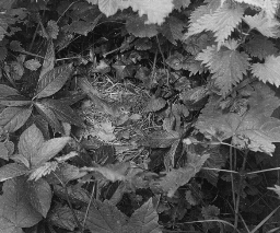 A Nightingale on Her Nest, England
A Nightingale on Her Nest, England
Perhaps no bird has figured in poetry so often as the nightingale. It is the bulbul of the Persian poets. It has been a favorite theme of English poets from Chaucer to Keats. Its song is sweet and full of melody, and carries a long distance. The fact that is sings after night, when all else is still, has made it popular. Here is a part of a poem that Keats wrote about it, as he listened to its night song through his open window. The bird is described as flying from one thicket to another far away: Adieu! adieu! thy plaintive anthem fades, Past the near meadows, over the hill stream, Up the hillside, and now 'tis buried deep In the next valley-glades: Was it a vision, or a waking dream? Fled is that music:-Do I wake or sleep? It is the male bird that sings. He sings in fine weather in the daytime as well as at night. He can be heard only from early May to the middle of June, for he sings only till the young are hatched. The nest is begun in the early part of May. The birds of the species you see here are to be found only in central Europe and Africa. They go to Africa for the winter. In the spring they return to their summer haunts. They prefer thick woodsy spots in damp places. The nightingale is not a large bird. From the bill to the tip of the tail it measures only a half foot. What bird do you know of about the same size? It has a brownish back, and a buff-colored breast. Its eggs are generally brown. From 4 to 6 are laid in the nest. Of what is the nest built? Is it near the ground? Make a list of birds that nest on the ground; in bushes; in trees. How would you go about to take the picture you see here? Keystone ID: 21200 Note: All titles, descriptions, and location coordinates are from the original Keystone Slide documentation as supplied by the Keystone View Company. No text has been edited or changed. -
 A Russian Peasant Plowing
A Russian Peasant Plowing
Russia is a backward country in its industries. The peasants are not educated, and do their work in the same way and with the same tools that their grandparents did. In this view, the Russian farmer is turning the soil with a plow at which an American farmer would laugh. It is an old-fashioned, home-made, clumsy affair. It does not turn the top soil under properly, as you see. The harness of the horse is in keeping with the plow. In spite of poor farm machinery, Russia is an agricultural country. It buys most of its manufactured goods from other nations. It produces four-fifths of the flax of the world; one-fifth of the wheat and the sugar beets; and one-tenth of the cattle. Rye, barley, oats, hemp, and potatoes are widely grown. The bread of the peasant is made of rye flour. The farmer you see here may own this land; but he does not own it in the way we use the term. Each village and city holds the land for its peasant population. Every year the fields are parceled out to the village dwellers. But the ground is worked in common, and the people usually work together. At harvest times the crops are divided among the people by the village officers. The only part of the land the peasant really controls is a small garden on which his house sits. The government and the wealthy class hold much of the country in large estates. Russia has the greatest natural resources of any country in Europe. It has long stretches of fine farming land. It is rich in minerals of many kinds. Its forests are hundreds of miles in extent. None of these resources have yet been developed. Tell how plowing is done on the farms in your neighborhood. What is a peasant? Of what is your bread made? Keystone ID: 18101 Note: All titles, descriptions, and location coordinates are from the original Keystone Slide documentation as supplied by the Keystone View Company. No text has been edited or changed. -
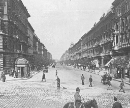 A Street in Budapest, Hungary
A Street in Budapest, Hungary
Hungary, a part of the Empire of Austria-Hungary, would make 3 states the size of Ohio. It is an agricultural country. Its principal crops are corn, wheat, barley, oats, and rye. Grapes are widely grown, and much wine is made. Tobacco and hops are important field crops. Its orchards produce apples, apricots, peaches, pears, and plums. Its forests are extensive. Oak, beech, and pine are its valuable trees. The mines and factories of Hungary are its other sources of wealth. Iron, coal, gold, and silver are the chief minerals. It manufactures clothing, foodstuffs, machinery, glassware, leather, chemicals, sugar, flour, and liquors. Budapest is the capital of Hungary. It is 160 miles southeast of Vienna, the capital of the Empire. The city is built on both sides of the Danube. On the right bank is Buda, a much older city than Pest, on the other side of the river. The two cities united in 1872. Pest is now much larger than Buda, and is a more modern city in all respects. Budapest has a population of about 880,000. Three-fourths of these speak the Magyar (md´ yr) tongue. The street you see here leads from the center of Pest, on the Danube, to the Town Park, 2 miles distant. It shows the extent of the city, and its fine buildings all of the same height. The height of all buildings is regulated by law. Near the spot you are standing are the fine Parliament Buildings. The city has many factories, and is especially noted for its flouring mills. It is sometimes called the Minneapolis of Europe. Why? The wheat grown in Hungary is of fine grade, and Budapest flour brings high prices in the European markets. The city was the first capital in Europe to use electricity for lighting and for driving street cars. Keystone ID: 15656 Note: All titles, descriptions, and location coordinates are from the original Keystone Slide documentation as supplied by the Keystone View Company. No text has been edited or changed. -
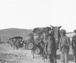
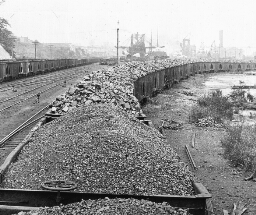 A Trainload of Coal from Pittsburgh Fields for Lake Superior Consumption, Conneaut, Ohio
A Trainload of Coal from Pittsburgh Fields for Lake Superior Consumption, Conneaut, Ohio
There is nothing unusual about this scene. On almost any of the great railways in the eastern and middle western sections of our country such trainloads of coal as this can be seen any day. But there is a particular interest connected with this and similar trainloads of coal running from the Pittsburgh district to the Great Lakes. Our greatest iron ore deposit lies at the western end of Lake Superior. In this district, however, there are no coal fields. One of two things must be done. Either coal must be taken to the ore fields, or the iron must be brought to the coal fields. Coal is needed to heat the iron so that it can be made into steel. When the Lake Superior iron district was first worked, all the ore was carried by huge lake boats to the coal district. But by this method, these boats had to return empty. This was a great waste. Now the shipping is carried forward both ways. Iron and steel refineries have been built in the Superior District. The vessels that bring iron ore to the east, carry back heavy cargoes of coal to be used in the Superior iron district. This trainload of coal that you see will be put on board one of these ships and unloaded at Duluth or Superior, not far distant from the iron ore area. This makes the ports along the southern shore of Lake Erie the natural exchange place of coal and iron. Among these important ports are Buffalo, Erie, Cleveland, Toledo, Ashtabula, Lorain, and Conneaut, the city here shown. Locate each of these cities on your map. Trace a shipment of coal from Conneaut to Duluth. Through what waters does it pass? Keystone ID: 6705 Note: All titles, descriptions, and location coordinates are from the original Keystone Slide documentation as supplied by the Keystone View Company. No text has been edited or changed. -
 A View of Quebec from Dufferin Terrace
A View of Quebec from Dufferin Terrace
Quebec is situated on a high cliff. This is formed by the union of the St. Charles and the St. Lawrence Rivers. Its location, its inhabitants, and its history make it one of the most remarkable cities in America. The people of the city and of the province of Quebec are largely French. You will recall this country was discovered, explored, and settled by the French, and that the city was the French capital of the New World. It was here that the supreme struggle between the English and the French in America took place. The view of Quebec and the surroundings from Dufferin Terrace is rich in its scenic beauty and in its suggestion of history. Directly below you is the Lower Town, as the section of the city is called which lies at the foot of the headland. There you see the winding streets, with their quaint old buildings on which are signs written in French. Beyond lies the majestic St. Lawrence, and the mouth of the St. Charles. On a clear day you can make out distinctly a town 35 miles down the river. The low banks are dotted with white villages, and with an occasional white house. At the south end of the Terrace is a citadel (st´ å-dl). This is a fortification on the highest point of the headland, covering 40 acres of ground. Dufferin Terrace is a large, wooden platform, 1/4 of a mile long and 50 to 70 feet wide. It is a sort of public promenade. Here hundreds of strollers march back and forth on a summer's evening, enjoying the scenery, the cool breezes from the St. Lawrence, and the music of the military band. Near by is the Wolfe and Mont-calm monument, erected in 1827 in honor of the two opposing English and French generals. Keystone ID: 13987 Note: All titles, descriptions, and location coordinates are from the original Keystone Slide documentation as supplied by the Keystone View Company. No text has been edited or changed. -
 A View of Vancouver, B.C.
A View of Vancouver, B.C.
You are here looking out over Burrard Inlet in which are built the wharves of the city of Vancouver. The depot and the wharves of the Canadian Pacific Railway are directly in front of you. The main portion of the city lies back of you on either hand. The entrance to the harbor is far out to the left. Vancouver gets its name from the British explorer who coasted up the western shores of North America, and discovered Puget Sound. This was in 1793, the year in which Washington began his second administration. The city was not founded, however, until 1885. In that year the Canadian pacific Railway selected it as its western terminus. The following year the little town was wiped out by fire. The town grew rapidly. By 1891 it had a population of more than 13,000. In 1911 its inhabitants numbered over 100,000. Though scarcely 40 years old, the city is now larger than Albany, N. Y. Vancouver is a lively western city. It has many manufactories. It makes machinery, furniture, carriages, flour, boots and shoes, and sugar. Ship building is also an important business. Commercially, the city is of chief importance as an exchange point. In its ports are vessels from China, Japan, San Francisco, Alaska, and near-by coastal cities. These vessels are laden with tea, silk, and sealskins, on their incoming voyages. They carry away heavy cargoes of lumber, coal, and wheat. The Canadian Pacific Railway taps the great timber region of the Rockies, and farther eastward the rich farming districts west of the Great Lakes. The city lies on a peninsula (pn-n´ s-lå) shaped like a half-formed fishhook. On the point of the peninsula is Stanley Park, containing 960 acres. It is beautifully wooded. Which way is Vancouver from your home? Keystone ID: 13837 Note: All titles, descriptions, and location coordinates are from the original Keystone Slide documentation as supplied by the Keystone View Company. No text has been edited or changed. -
 Aberdeen Angus, Noted Beef Breed, Scotland
Aberdeen Angus, Noted Beef Breed, Scotland
Cattle are roughly classed in two groups. One kind is dairy cattle, the other is beef cattle. These names tell you what each kind is noted for. Among the dairy cattle are Jerseys, Ayrshires, Guernseys, and Holstein-Friesian. The best known of the beef cattle are the Herefords, the Shorthorns, the Galloways, and the Aberdeen Angus. Nobody knows just when the Aberdeen Angus breed was begun, but it must be an old race of cattle. It has long been the most popular kind of cattle in several of the coast counties of northeastern Scotland. Among these is the county from which the first half of the name comes. The "Angus" comes from the district in which the Aberdeen herds are best known. About a hundred years ago the cattle raisers of these Scotch counties began to perfect the breed. It is now one of the important beef types of cattle. There are many marks that set the Aberdeen Angus off from the other kinds of beef cattle. Herefords have white faces and legs. Shorthorns are red and white, and have drooping horns. Galloways have no horns, are black in color, but are smaller than the Aberdeen Angus. The Aberdeen Angus is black and hornless. Their hair is short and smooth. Galloways are shaggy. The Angus have high foreheads and tapering hips. Their necks and forequarters are heavy. They are fine, active cattle. The breeders of these cattle claim that the meat of the Aberdeen Angus is better flavored and more finely grained than that of any other kind. What breeds of beef cattle are common in your county? If you do not live in the country, ask your butcher. Find out what breed of cows furnishes the milk you drink. Keystone ID: 21501 Note: All titles, descriptions, and location coordinates are from the original Keystone Slide documentation as supplied by the Keystone View Company. No text has been edited or changed. -
 Above the Clouds, on Mount Pilatus, Switzerland
Above the Clouds, on Mount Pilatus, Switzerland
You might think that this is a picture of a fort overlooking a lake. The building is a hotel on top of Mt. Pilatus. And what appears to be water is clouds. You are looking on a strange world. It is the kind of sight that aviators (´ v-´ tr) get in mountainous country when high up in an aeroplane (´ r--pln). Mt. Pilatus is near Lake Lucerne (l-sûrn´). Its highest peak is 6,995 feet above sea level. It is possible to climb the mountain on foot, but it is a hard journey. Some of the paths to the top are not very safe. Most people now go up the mountain by the cogwheel railway. This railway is almost 3 miles long, and reaches a point over a mile above its beginning. It is a ride that travelers to Switzerland cannot miss. On top of the mountain the view is wonderful. Mt. Pilatus itself has 10 peaks, all rough and jagged. If the day is clear, the traveler can look out over peak after peak of the Alps. To the eastward lies beautiful Lake Lucerne. Due north a few miles is the city of Lucerne. Mt. Pilatus used to be called the Broken Mountain. This describes it better than the name it now bears. The mountain is formed of a kind of limestone. The Lake Lucerne district draws more visitors than any part of Switzerland. The lake is 1,500 feet above sea level, and the mountains above it are sights of changing beauty. To the Swiss it is very dear on account of William Tell, the Swiss hero. You will observe in the picture the way in which the roads and paths are cut into the peak. Note also the sharp sides of the neighboring peak. Locate Lake Lucerne on your map. What do you know about William Tell? Keystone ID: 10798 Note: All titles, descriptions, and location coordinates are from the original Keystone Slide documentation as supplied by the Keystone View Company. No text has been edited or changed. -
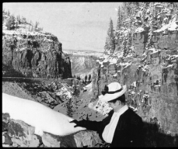 After Winter's First Visit-gap of Golden Gate, Yellowstone National Park, Wyoming
After Winter's First Visit-gap of Golden Gate, Yellowstone National Park, Wyoming
Yellowstone Park is chiefly in the extreme northwestern part of Wyoming, but a small strip of it some 3 miles in width is in Montana, and it extends about 11 miles into Idaho. It contains 3300 square miles. It is a national park; that is, it is controlled by the United States Government. A park superintendent has charge of it. He is appointed by the Secretary of the Interior. He has a body of soldiers to enforce his orders. The first visit to the Yellowstone Park of which there is any record was made by John Colter in 1810. Colter was on his way home by himself from the famous Lewis and Clark expedition. He took refuge in what is now the park, to escape from the Indians. A trapper named Joseph Meek, in 1829, visited the region and described its geysers and hot springs. A government expedition in 1859 carefully explored and charted the district. Finally in 1870 Henry D. Washburn led an exploring expedition into the Yellowstone area and established the facts concerning it. Two years later it was set apart as a public pleasure ground and as a game preserve. You are here looking at the gap of the Golden Gate. This is a narrow valley overtopped by great hills. The view shows the wonderful beauty of the spot in midwinter. The many colored hills, topped with evergreen trees, with the winter snow caps about, give a wonderful variety of color. How does the Yellowstone Park compare in size with the state of Delaware? Connecticut? Locate it on your map. Tell something of its history. Keystone ID: 13579 Note: All titles, descriptions, and location coordinates are from the original Keystone Slide documentation as supplied by the Keystone View Company. No text has been edited or changed. -
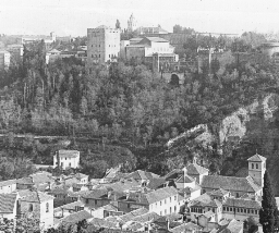 Alhambra Palace, Granada, Spain
Alhambra Palace, Granada, Spain
The Moors held Spain for a number of centuries. Their capital was at Granada (grä-nä´ dä), and their palaces are called the Alhambra. One of the palaces only is properly named the Alhambra, that is the Palace of the Moorish Kings. But the name is now applied to the many buildings. The Alhambra sets on a hill surrounded by deep ravines. It was well placed for defense against a foe in the Middle Ages. The first palace was built by Mohammed I, in the 13th century. Succeeding kings built the finest of these-the Court of the Lions, so named because twelve lions bear a large fountain basin in the center of the court. Under King Ferdinand and Queen Isabella the Moors were driven out. King Ferdinand tore down part of the Alhambra and built a new palace. Since then wars and neglect have further destroyed the fine old structures. But many of the ruins have been restored. Now the Alhambra belongs to the government and is well cared for. It is one of the wonder spots of Europe. The bright colors of the desert, mingled with the Eastern idea of carving, give the whole place an out-of-the-world appearance. It is said that the coloring was made as magnificent as that of the rugs of the East. The view you get in the picture suggests the great size of the Alhambra and the many kinds of buildings it contains. If you wish to have a vivid account of the old Moorish palace read Irving's The Alhambra. Where have you heard before of Ferdinand and Isabella? Who are the Moors? Where is this race of people now found? Is Spain considered one of the great countries of the world today? Was it ever so considered? What was the Spanish-American War about? Keystone ID: 967 Note: All titles, descriptions, and location coordinates are from the original Keystone Slide documentation as supplied by the Keystone View Company. No text has been edited or changed. -
 Along the Danube Canal in Vienna, Austria-hungary
Along the Danube Canal in Vienna, Austria-hungary
The Danube, next to the Volga, is the largest river in Europe. It is about the length of the Rio Grande, but it is far more important. It is the only long southern highway of fresh water between eastern and western Europe. It rises in south Germany where one of its arms is linked by a canal with one of the tributaries of the Rhine. Eastward and southward it takes its course across Austria-Hungary, bordering Serbia on the north. For 350 miles it is the boundary between Roumania (r-m´ n-å) and Bulgaria (bl-g´ ri-å). Finally it turns northward across Roumania, and marks the line of separation between that country and Russia. It empties into the Black Sea. The river touches or crosses 5 countries, 3 of which are powerful empires. On its banks are the capitals of two nations and one dependent country. These are Vienna (v-n´ å), Belgrade (bl´ grd´), and Budapest (b´ då-pst´). About 3 miles northwest of Vienna the river breaks through hills of limestone into the Viennese valley. The main body of the river flows on the north of the city. To keep it from flooding, the river has been made into a canal for a distance of 8 miles at a cost of nearly 15 million dollars. The river branches just outside of Vienna so that one arm flows through the heart of the city. This, too, has been made into a canal-the one you see. On either side, and floating on the canal, are warehouses and fish depots (d´ p). On the canal is carried a great deal of the city's freight traffic. It is fitted up with fine stone and concrete quays (k). At either end of it, where it connects with the Danube, are winter harbors. The canal was built in 1869-73. Keystone ID: 5607 Note: All titles, descriptions, and location coordinates are from the original Keystone Slide documentation as supplied by the Keystone View Company. No text has been edited or changed. -
 An Alpine Glacier, Chamonix, France
An Alpine Glacier, Chamonix, France
France is a large nation with many kinds of country and people in its borders. Its western borders are washed by the Atlantic. Its southwestern boundary is the Pyrenees (pr´ -nz) mountains. Its fair fields of the south slope toward the sunny Mediterranean (md´ -tr-´-n-n). In the north it looks over Belgium and the uplands of the Rhine. On the east it rises ruggedly into the tall peaks of the Alps. It is a land of over 200,000 square miles and 40,000,000 people. It would make 5 states the size of Ohio, with 9 times as many inhabitants as Ohio has. Some of these are the gay Parisians, others the slow-moving fishermen of the coast, and still others the active mountaineers of the Alps section. It is here you see a section of France that tourists love even beyond Paris. This is the valley of the Chamonix (shå´ m´ n´). The valley is only 12 miles long and a half mile wide, but it has some of the finest scenery of Europe. It is bordered on the southeast by the Mont Blanc chain of Alps, and Mont Blanc is the highest of all Alpine peaks. It rises 15,782 feet above sea level. The glacier you are looking at is the snow and ice from the peak of Mont Blanc ("white or snow mountain".) There are 19 other glaciers that are fed by the Mont Blanc snows. On the left hand you see a peak called Aiguille du Mid, which means the Central Peak. Glaciers are formed by layers of snow and ice and are years and years in the making. Heavy snows fall on Mont Blanc in the winter. They thaw in the summer, freeze and thaw again, till a sheet of great thickness and weight is formed. Finally the weight is so heavy that the pressure forces the ice sheet slowly downward. Keystone ID: 10732 Note: All titles, descriptions, and location coordinates are from the original Keystone Slide documentation as supplied by the Keystone View Company. No text has been edited or changed. -
 An Arabian Sheik, Syria
An Arabian Sheik, Syria
Here you have a picture of an Arab chief in the country of Syria. Sheik (shk) is the name used instead of chief. The word means an elder or a chief. It is used of any person of high standing among the Mohammedans (m-hm´-d-an). The sheik is here waited upon by his bodyguard, the man holding his horse. The Sheik and his man are both armed with rifles. The country of Syria is not safe for travelers. There are bands of desert robbers always on the lookout for unprotected persons or caravans (kr´ å-vn). Observe the cartridges in the sheik's belt, his dress, his sword. The sheik is wearing a white robe. This means he is a man of wealth or power, or both. He is proud of his steed, as he well may be. It is said that the Arab prizes his horse more than his wife. It was from these fast, well-bred horses of the Arabs that our fine race horses have come. In such cities as Damascus, however, the sheiks usually ride on white donkeys. But on the plains and in the desert the faithful horse is needed because of his speed. Why? Syria is the name loosely given to that part of Asia Minor lying northwest of Arabia and northeast of Palestine. Damascus is its queen city. Beirut (b-rt´) is its chief port. It includes the old land of Phoenicia (f-nsh´ -ä), the home of the famous sailors of King Solomon's time. Its western part has a great deal of rain, and is well wooded. Its eastern part is a desert waste. A railroad runs from Aleppo southward through Damascus. Syria is not an important country to-day, but its history is a long and interesting one, and worth your reading. Locate Damascus; Beirut. On what sea does Syria border? Keystone ID: 20703 Note: All titles, descriptions, and location coordinates are from the original Keystone Slide documentation as supplied by the Keystone View Company. No text has been edited or changed. -
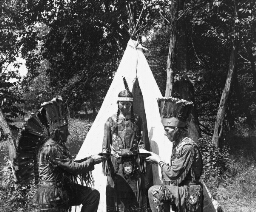 An Indian Maiden and Two Braves, Minnesota
An Indian Maiden and Two Braves, Minnesota
Brought forth food and set before them, Water brought them from the brooklet, Gave them food in earthen vessels, Gave them drink in bowls of bass-wood, Listened while the guest was speaking, Listened while her father answered, But no once her lips she opened, Not a single word she uttered. This quotation from Hiawatha tells you a number of things about Indian life. Hiawatha had come there for the maiden, Minnehaha, the Laughing Water. It was her duty to serve in silence, not only the guest, but her father as well. The duty of the Indian woman was to serve. She did not sit in the council of the warriors nor was she consulted on the affairs of the tribe. She it was who tended the corn, who tanned the hides, who moved the tepee when a new hunting-ground was to be sought out. Yet, in her own way she was happy. You will not fail to study the dress of both chieftain and maiden. Notice particularly the headdress, the leggings, and the beautiful beadwork. The board band of beads was one of the commonest and one of the most beautiful of an Indian woman's decorations. Behind the maiden is the little tepee. In this sort of tent the Indians lived when on a hunting expedition. This is the way that Hiawatha asked for the hand of Laughing Water. After many years of warfare, Many years of strife and bloodshed, There is peace between the Ojibways And the tribe of the Dacotahs..... That this peace may last forever, And our hands be clasped more closely, And our hearts be more united, Give me as my wife this maiden, Minnehaha, Laughing Water, Loveliest of Dacotah women! Keystone ID: 11942 Note: All titles, descriptions, and location coordinates are from the original Keystone Slide documentation as supplied by the Keystone View Company. No text has been edited or changed. -
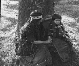 An Indian Mother and Her Child, Michigan.
An Indian Mother and Her Child, Michigan.
There the wrinkled, old Nokomis Nursed the little Hiawatha, Rocked him in his Linden cradle, Bedded soft in moss and rushes, Safely bound with reindeer sinews; Stilled his fretful wail by saying, 'Hush! The Naked Bear will get thee!' Lulled him into slumber, singing, 'Ewa-yea! My little owlet! Who is this, that lights the wigwam? With his great eyes lights the wigwam? Ewa-yea! My little owlet!' This Indian baby is not bound with reindeer sinews, but he is safe in his Indian cradle. This cradle the mother straps to her back when she carries her child through the woods. You will observe his beautiful Indian blanket. The pattern woven into it is one common to the throws and blankets the Indians weave. About the head the mother is a band of beads in which are stuck two turkey feathers. Her dress is decorated with strips of leather and bits of shell. Her moccasins are beaded, as is also the bag by her side. Her hair hangs down in two heavy plaits. Nokomis taught Hiawatha: Many things Of the stars that shine in heaven; Showed him Ishkoodah the comet, Ishkoodah, with fiery tresses; Showed the death dance of the spirits, Warriors with their plumes and war clubs, Flaring far away to northward In the frosty nights of Winter; Showed the broad, white road in heaven, Pathway of the ghosts, the shadows, Running straight across the heavens, Crowded with the ghosts, the shadows. When the little papoose grows older he will learn to shoot the bow, to wrestle, to ride, to fish, to jump, and to use the knife and hatchet. Keystone ID: 11941 Note: All titles, descriptions, and location coordinates are from the original Keystone Slide documentation as supplied by the Keystone View Company. No text has been edited or changed. -
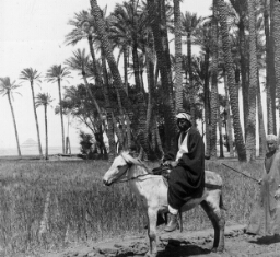 Ancient and Modern Egypt, Sakkara
Ancient and Modern Egypt, Sakkara
Here, near the old city of Memphis, you get a view of Egypt of the present and the Egypt of the past. In the foreground is a native nobleman, out for a pleasure ride. With him is his attendant. In the background is one of the oldest stone buildings in Egypt. This building as you see is a pyramid built in steps. It is called the Step Pyramid. It was built by King Zoser nearly 5,000 years ago. It is made up of six steps, which you can make out easily in the picture. The steps range from 29 to 37 feet in height, so that the top is 200 feet above the desert. The Step Pyramid is one of the landmarks of the country. The nobleman you see is called a "bey" (b). The beys were formerly rulers of Egyptian states or provinces. But now the name is given to any man of noble birth. His dress shows you the kind of clothes the better class of Egyptians wear. His steed is the common one used up and down the Nile. On the desert the camel is the beast of burden. Study the view for a notion of the way Egypt looks. Observe also the giant date palm trees. Tell all you can find out about the use of these trees to the people of Egypt. Keystone ID: 9771 Note: All titles, descriptions, and location coordinates are from the original Keystone Slide documentation as supplied by the Keystone View Company. No text has been edited or changed. -
 Ancient Method of Threshing, Greece
Ancient Method of Threshing, Greece
Greece is a farming country. About one-fifth of the land is cultivated, one-third is in pasture and meadow, and one-eighth in forest. The rest is waste. The land is owned chiefly in small tracts by the farmers. The summer climate is dry. There are only a few rivers, and but little has been done toward irrigation and ditching. Agriculture is in a backward state. This is shown in the scene before you. Here grain is being threshed by a method almost as old as the country. A stretch of ground in a field is leveled for a threshing floor. The grain cut and bound by hand, is hauled to the field. You see long stacks of sheaves in the background. A few loads are hauled to the threshing floor, the sheaves are opened, and the grain scattered on the ground. Mules and horses are driven over it, around and around, back and forth. When the straw is trodden down tightly it is lifted up by forks, and the animals repeat their marches. When most of the grain is freed from the heads, the straw is piled in bunches. The chaff and grain are thrown against the wind until they are separated. Our ancestors in America threshed wheat in the same way generations ago. You will realize how old-fashioned this method is if you think of the way in which wheat and oats are harvested in our grain-producing areas. We do out harvesting by modern machinery. But little work by hand is needed. You will observe the quaint wooden pitchfork the men use, and the patched-up rope harness the animals have. Greece grows annually about 12 million bushels of wheat. Other grains raised are barley, rye, and corn. Half the tillable land of the country is set to grain. Keystone ID: 7170 Note: All titles, descriptions, and location coordinates are from the original Keystone Slide documentation as supplied by the Keystone View Company. No text has been edited or changed. -
 Andalusian Carts Coming Into Almeria, Spain
Andalusian Carts Coming Into Almeria, Spain
Andalusia (n´ då-l´ sh-å) is the name given to the southern part of Spain. It is a country long known to civilized peoples. It is referred to in the Bible as Tarshish (tär´ shsh), where it is mentioned as a land of silver and gold. It was from this section that the Phoenicians (f-nsh n), who sailed forth from Tyre (tr), got a large part of their silver, and some of their gold. The Phoenicians were the greatest sailors of ancient times, and the finest workmen of precious metals. They founded the city of Cadiz (k´ dz) over 3,000 years ago. The province finally came under the control of the strong nation of Carthage. Then the Romans conquered Carthage and thus came into possession of Andalusia. From the 8th to the 13th centuries the country was held by the Moors. The Arabs named it El Andalus, meaning "The Western Land." The peasants of Andalusia are very different from the pure Spanish. Most of their words for common things are Arabic. Their dances and games are those of the East. They are noted for their active imaginations, and for their keen wit. It is from this section of Spain that the famous bullfighters have come. Here you see the country lads bringing to town barrels of grapes on two-wheeled carts drawn by mules. You will observe that these mules are hitched in tandem. Almeria (äl´ m-r´ ä), the city to which the carts are bound, is an excellent port on the Mediterranean (md -tr-´ n-n). One of the chief exports is grapes, shipped in barrels such as these you see. Spain is an important country in the production of grapes. It has over 3,000,000 acres under vines. Keystone ID: 15828 Note: All titles, descriptions, and location coordinates are from the original Keystone Slide documentation as supplied by the Keystone View Company. No text has been edited or changed. -
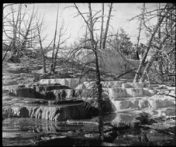 Angel Terrace, Yellowstone National Park, Wyoming
Angel Terrace, Yellowstone National Park, Wyoming
This is a section of the hot springs area in the Yellowstone National Park. These springs have built up terraces, as you see, of limey deposits. These deposits are formed partly because of the cooling of the water, and partly because of the plants which are submerged in the water. The entire region of the Yellowstone is volcanic in formation. That is, the interior heat of the earth comes very near to the surface in this district. In some places the waters are heated, steam is formed, and the overlying surface water is blown far up into the air. These are called geysers. In other spots the boiling-hot water trickles out of the rocks. These are the hot springs. Among the hot springs here shown, you may pick your way around if you watch your step. The pools look to be vividly colored. Some of the deep ones are very green. In others the springs of grass and flowers appear to be painted over with a coating of fine silver. Yellowstone Park is a land of wonders. It is the largest of all our national parks. It is kept in its wilderness states so it is not only a pleasure park, but it is also a retreat for thousands of wild animals. Antelopes, elks, bears-all the wild animals native to this section of the Rockies -are protected within the Park limits. Within its 3300 square miles are more geysers than can be found in all the rest of the world put together. Its hot springs are countless. It has swift rivers, large lakes, deep canyons (kn´ yn), and great stretches of petrified forests. Here, too, are large hotels and camps for the public. The park contains 200 miles of first-class roads. Explain how hot springs are formed. In what other parts of the United States are hot springs found? Keystone ID: 13588 Note: All titles, descriptions, and location coordinates are from the original Keystone Slide documentation as supplied by the Keystone View Company. No text has been edited or changed. -
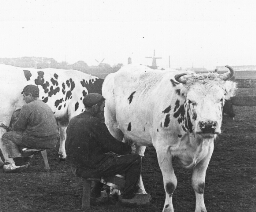 At Milking Time on a Dutch Farm
At Milking Time on a Dutch Farm
The Dutch have never been such noted farmers as their neighbors, the Belgians. They are shrewd traders, stubborn warriors, and bold sailors, as their history fully relates. They hold colonies far over the seas, and they have great cities. The Dutch flag flies in every great harbor of the world at the masts of a Dutch trading vessel. It was the Dutch who were the chief rivals of England for the control of the seas in days gone by. But they have also always been lovers of cattle and of the products of the dairy. The country along the Rhine was settled by the Friesians and Bavarians who brought their herds with them. An early Roman historian tells of their great herds of cattle. The cows you see in the picture came from this same stock of cattle. They are called Holstein-Friesians. You will find plenty of the same breed in the United States. And many kinds of dairy cattle in Europe have come from this stock. The Holsteins are all colored as these cows here. They are white with black spots and patches. They give great quantities of milk, which is not very rich in butter fat. They get their growth early, can stand harsh climates, and are of gentle disposition. There are now in northern Netherlands about 100,000 of these cattle. It is no wonder that the Dutch have a great name as butter and cheese makers. This is a typical Holland scene. The country is so flat you can see almost all of it from a tower in the center. In the background of the view you see the four-armed windmills for which Holland is famed. These mills furnish power to pump water, grind feed, etc. What colonies in America did the Dutch settle? What colonies in the world do they now control? Keystone ID: 12201 Note: All titles, descriptions, and location coordinates are from the original Keystone Slide documentation as supplied by the Keystone View Company. No text has been edited or changed. -
 At Work on a Turpentine Farm, Savannah, G.A.
At Work on a Turpentine Farm, Savannah, G.A.
Turpentine, tar, pitch, and rosin are made from the sap of the longleaf pine. This tree grows along the Atlantic Coast from North Carolina to Florida. You can see here how the sap of the tree is obtained. A notch, called a box, is cut at the foot of the tree. Above this box the bark is scarred or gashed so that the sap, in the spring, oozes out and runs into the box. The man at the right is chopping the bark. The man on the left is dipping the turpentine from the box into the keg. When the kegs at the various trees are full, they are gathered up and taken to a distillery (ds-tl´r-). At the distillery the sap is boiled and the turpentine, in the form of vapor, rises into pipes. These pipes are cooled by spring water. This cooling condenses the turpentine, which then runs into barrels. The barrels are sealed and hauled to a shipping point. The United States leads all other countries in the production of turpentine, rosin, and tar. Nine-tenths of these so called "naval stores" come from the turpentine farms in our Southern Atlantic States. North Carolina formerly led in their production. But the trees of this state have been pretty well used up, so that Georgia and Florida now lead. Savannah is the chief port of shipment for naval stores. A turpentine farm contains thousands of trees. These trees, as you see, are not large, but they are tall and very straight. They are scarred from the box up to the height of a man's head. The size of a farm is reckoned by the number of boxes producing turpentine. Some farms have millions of boxes and employ small armies of negroes, who work in gangs under an overseer. Keystone ID: 13747 Note: All titles, descriptions, and location coordinates are from the original Keystone Slide documentation as supplied by the Keystone View Company. No text has been edited or changed. -
 Automobile Manufacture, Michigan
Automobile Manufacture, Michigan
This is the interior of a great automobile factory. Row after row of chassis are here to be seen. On the left hand, differentials and rear axles are being assembled. When this assembling is done, the chassis are equipped with the motors and the machine is set running while the wheels are off the floor. Then each chassis is equipped with the tester's seat and is given a trial drive before the body is put into place. Not every automobile factory makes all its parts. In some plants these parts are merely assembled. That is, the ball bearings may be made in Philadelphia, the steel frame work in Pittsburgh, the tires in Akron, and so on. Each of these special factories may supply a number of automobile manufacturers with its speciality, made according to certain specifications. The automobile factory puts these together, and so turns out a finished car. Our output of these machines is increasing rapidly. In 1916 we made about 70% more than in 1915. In 1915 we produced 75% more than the year before. Most of our importations of rubber are for automobile tires. In 1915 we shipped into this country $159,000,000 worth of rubber. Gasoline by millions of gallons is needed to furnish motive power. Our whole industrial development has been changed by the automobile. Motor trucks haul grain and livestock to market. They transport great loads of raw materials and finished goods in our cities. Traffic on our city streets has been completely changed. It moves far more swiftly than previously. Farmers are no longer several hours' travel from cities. Distance has been shortened, and time gained by the introduction of this modern machine. Keystone ID: 22141 Note: All titles, descriptions, and location coordinates are from the original Keystone Slide documentation as supplied by the Keystone View Company. No text has been edited or changed. -
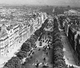 Avenue Des Champs Elysees, Paris, France
Avenue Des Champs Elysees, Paris, France
The great city of Paris lies on both sides of the River Seine. The larger portion lies on the northern side of the river. The finest street and the chief thoroughfare is a long avenue that runs from southwest to northeast. Parts of this avenue bear different names, but it is all one highway. One section is the Champs Elysees (shän´ z´ l´ z´) that is, the "Elysian Fields." The Champs Elysees is over a mile in length. Two lines of trees border the roadway and shade the sidewalks. But no grass is to be seen anywhere. This is the fashionable drive and walk of Paris. In the afternoon and evening automobiles and carriages line the streets in great processions. Strollers parade the sidewalks. Beneath the trees there are all kinds of amusements. Swings, merry-go-rounds, Punch-and-Judy shows, vaudeville performances, dancing, sleight of hand jugglers-the whole street is a world of amusement in itself. You can sit at one of the tables under the trees and be served with food and drinks. Here you can enjoy the passing show of fine vehicles or watch the strollers display their new suits and dresses. A few feet away a crowd of children are laughing at the antics of Punch and Judy. Beyond, another crowd is waiting to clamber on a little merry-go-round. This is Paris-the fair city of a smiling people. But it has not always been thus on this street. Down this avenue kings and queens have been dragged to dungeon or to the headsman's axe. Soldiers have fought here with the French mobs, and the street has rumbled with the wheels of the carts carrying away the executed. Some day you will read the dreadful story of the French Revolution and then you will recall this scene of the Champs Elysees. Keystone ID: 1641 Note: All titles, descriptions, and location coordinates are from the original Keystone Slide documentation as supplied by the Keystone View Company. No text has been edited or changed. -
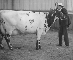 Ayrshire Type of Dairy Cattle, Scotland
Ayrshire Type of Dairy Cattle, Scotland
Ayrshire cows are bred chiefly for dairying. Jerseys, Ayrshires, Guernseys, and Holstein-Friesians are the four great dairy breeds. The milk of the Ayrshires is not so rich in butter-fat as is that of the Jerseys. But the Ayrshires produce more milk than the Jerseys. On this account Ayrshires are raised on large dairy farms where milk rather than butter is wanted. Some dairymen pay most attention to bottling and selling milk. Others interest themselves largely in making butter. The choice of cattle to fit the needs of each is very important. An Ayrshire cow has been known to produce 11 tons of milk in a year. This was 16 times the weight of the cow. The cow here shown is a fine likeness of the breed. Ayrshires are mostly white in color, with red or brownish spots and patches. They have long upturned horns with black tips. They are a fifth larger than Jerseys, and weigh from 1000 to 1400 pounds. They have straight backs. Their udders are large. They are a bit nervous, as is shown by the way this cow holds herself while having her picture taken. The Ayrshires come from the mixing of many breeds. The breed sprang up in southwestern Scotland in the county of Ayr. The blood in their veins likely comes from the following breeds: Highland, Teeswater, Shorthorn, and Hereford. It was not till after 1850 that the fine points of the new breed were set down. Then the Ayrshires improved rapidly because breeders knew what to select for breeding purposes. Find Ayr on your map. From what breed of cows does the milk come that you use? The butter? What breeds of cattle do you know? Name the differences between an Ayrshire and a Jersey. Keystone ID: 21502 Note: All titles, descriptions, and location coordinates are from the original Keystone Slide documentation as supplied by the Keystone View Company. No text has been edited or changed. -
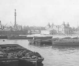 Barcelona, Spain, from the Harbor
Barcelona, Spain, from the Harbor
Barcelona (bär´ s-l´ nä) is the liveliest city in Spain. It is as large as Baltimore, and leads all other Spanish cities in commerce and manufacturing. Ships flying the flags of all nations drop anchor in its harbor. Iron foundries, machine shops, silk mills, cotton mills, chemical works, flour mills, and chocolate factories send their smoke against the foothills of the Pyrenees. Barcelona seems to belong to another world from that of Madrid (mä-drd´) or Granada (grä-nä´ dä). It is more like the cities of France, England, or Germany. Barcelona was a city when Augustus Caesar ruled in Rome. Its name is said to come from that of a famous general (Hamilcar Barca) of Carthage, when Carthage was fighting Rome for control of the Mediterranean (md -tr-´ n-n). That was centuries before Rome had known a Caesar. Barcelona has therefore a long history. In Columbus' day, it was rival of Venice and Genoa for the Mediterranean trade. Perhaps it was Barcelona's fame that led Columbus to seek Spanish aid, when his native Italy failed him. Anyway it is fitting that a great monument to Columbus should watch over Barcelona harbor. It was Spain that gave the great sailor to the world; and Barcelona has been, and is, the center of Spanish shipping. It is this monument you see beyond the vessel on the left of the view. The monument is 200 feet high. On its top is a gilded ball. On this stands a statue of Columbus 23 feet high. At the base of the monument stand 8 bronze lions; and there are scenes from the life of Columbus done in bronze. Where was Columbus born? Why did he go to Spain? From what port in Spain did Columbus set sail? Keystone ID: 15808 Note: All titles, descriptions, and location coordinates are from the original Keystone Slide documentation as supplied by the Keystone View Company. No text has been edited or changed. -
 Battle With a Wounded Alligator, Palm Beach, Florida
Battle With a Wounded Alligator, Palm Beach, Florida
Here is one of the terrors of our southern rivers. Alligators are as much dreaded by bathers in the rivers that flow into the Gulf of Mexico, as are sharks along warm sea beaches. The one here shown has been wounded by a famous hunter. The reptile, even though crippled, has seized the barrel of the rifle. The hunter will doubtless make short work of him. Alligators are of close kin to crocodiles. In fact, you would have some difficulty in telling the two apart. =Alligators live chiefly along the streams of the southeastern United States. There is one kind found also in China. They grow to be almost twenty feet in length, but they do not become full sized until they are about 100 years old. The female lays her eggs in the mud and grass on the banks of a stream, in the late spring. These eggs number from 100 to 200. She watches over them until the warm sun hatches out the little creatures. She then leads them down to the water and gives them there first lesson in swimming. There are not nearly so many of these animals in our southern rivers as there formerly were. This is largely because hunters have killed them. Formerly the animals were shot because of the fear people had of them. Now they are hunted because of their skins and their teeth. Their skins make fine, soft leather. You have doubtless seen bags and belts made of alligator hides. Their teeth are valuable because of the ivory they contain. What other large animals do you know that live in the rivers of warm countries? Look carefully at this view and describe an alligator so that your classmates would recognize one. Keystone ID: 13749 Note: All titles, descriptions, and location coordinates are from the original Keystone Slide documentation as supplied by the Keystone View Company. No text has been edited or changed. -
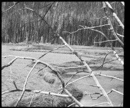 Beaver Dam, Yellowstone National Park, Wyoming
Beaver Dam, Yellowstone National Park, Wyoming
Beavers are the largest of our gnawing animals. They sometimes weigh as much as 50 pounds. They are coated with a fine, soft fur which has made them the prey to hunters and trappers. They have a peculiar flat tail that is covered with scales instead of hair. This tail is 8 or 9 inches long and 4 inches wide. It is shaped like a paddle and is used by the animal as a propeller when he swims and as a trowel when he works at his trade on building. The beaver is the most wonderful builder of any our mammals. His home is a marvel of architecture-as marvelous as that, of the honeybee or the ant. The dam that he builds across rivers is to give him a body of deep water where his enemies cannot seek him out. In the bottom of his lake he lays up his winter supply of food. This food consists of the inner bark of trees. Before building a dam the chief engineer among the beavers selects a favorable place in the stream for its location. He never makes a mistake in choosing a likely spot, nor does he make his choice during high water. Immediately, work is begun. Trees are gnawed down, their limbs are cut into sections about 6 feet long, and even great sections of the trunk are gnawed in two. Sometimes 3 or 4 beavers will work together to roll a tree trunk into the stream. The dam here is 600 feet long. There are no beavers in this lake now. Some of their dams are two-fifths of a mile in length and 20 feet wide at the base. The logs and limbs are plastered together with mud which the beaver carries in great armloads with his front paws. They are such energetic little beings that we speak of an industrious person as one who "works like a beaver". Keystone ID: 13594 Note: All titles, descriptions, and location coordinates are from the original Keystone Slide documentation as supplied by the Keystone View Company. No text has been edited or changed. -
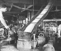 Beet Pulp and Juice Flowing from Tank to Tank, Montreal, Canada
Beet Pulp and Juice Flowing from Tank to Tank, Montreal, Canada
A great deal of the juice flows from the beets in the slicing machine. This juice, with the thinly sliced beets, is seen here pouring from the slicer, into the top of the first of a series of tanks. These tanks are arranged in batteries connected by large pipes. Only the tops of the tanks, with their screw caps, can be seen here. When the tank directly behind the workman is full of juice and slices, the flow is turned off. Then the workman in the foreground moves the chute and places the lid on top of the tank. It is the fastener of this lid that the workman is holding. Through the pipes, warm water flows slowly from one tank to another. In each tank the slices have more and more of their juice soaked out by the water. By the time the last of the 12 or 14 tanks in the circuit has been reached, the juice is very thick. It is then drained off and is ready for the next process, that of filtering. Lime is now mixed with it, and the juice is now cleaned by turning gas into it. The juice is next filtered, so that it is a very clear, syrupy fluid. The filtered juice is now ready for the heating. The purpose of the heating is to gather together the particles of sugar by evaporating (-vp´ -rt´ ng) the water from them. The air is pumped out of the heating tanks so that the sirup boils at a low temperature. The heating is usually done by steam. In these tanks, the sugar forms into grains, and is gathered together in a centrifugal (sn-trf´ -gl). This is a revolving sieve, which throws off the remaining moisture in the sugar. Further refining and purifying take place, until at last we have a fine quality of beet sugar. Keystone ID: 20944 Note: All titles, descriptions, and location coordinates are from the original Keystone Slide documentation as supplied by the Keystone View Company. No text has been edited or changed. -
 Beets Stored in Bins, Montreal, Canada
Beets Stored in Bins, Montreal, Canada
When sugar beets are pulled, their tops are cut off, and their roots are stacked in great piles. Sometimes these piles are made in the fields where they are grown, and the beets are hauled later to the sugar factory. Such piles are to be seen frequently in Colorado, where there is little rainfall. The heaps are often higher than a man's head, and cover large areas of ground. The roots must be stored indoors before frost comes. They usually are hauled to the factory, where they are dumped into bins such as you see. The beets here have been unloaded from freight cars, into the storage shed. The bins inside these sheds are V-shaped. At the bottom of the bin are little canals through which a stream of water runs to carry the beets to a large washing drum. This drum is partly filled with water. As it turns over and over, the beets are thoroughly washed. You will observe that this pile consists of tons and tons of beets. They are larger than the garden beet, and more irregular in form. They look here somewhat like huge, pointed sweet potatoes. The channel in which the water flows is directly beneath the little valley that extends between the beet ridges the entire length of the shed. After the beets are washed they fall into a chute which carries them to the floor below. Here they drop into a huge slicer, equipped with large knives that revolve from 100 to 150 times a minute. These cut the beets into strips or slices. Different methods are used in different factories to extract the juice from the slices. In some factories the pieces are run through presses, and the juice is squeezed out the same way that cider is squeezed from apples. But there is a less expensive way shown in view 271. Keystone ID: 20941 Note: All titles, descriptions, and location coordinates are from the original Keystone Slide documentation as supplied by the Keystone View Company. No text has been edited or changed. -
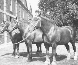 Belgian Draft Horses
Belgian Draft Horses
A horse must weigh over 1500 pounds to be classed as a draft horse. Belgian draft horses weigh from 1,600 to 2,300 pounds. They are about the same size as other draft horses, such as the Percheron, the French Draft, the Shire, the Suffolk, and the Clydesdale. But they differ from these other breeds in many ways. The Clydesdale and the Shire have long hair on the lower part of their legs. The body of the Belgian is heavier and fuller than that of any of the other draft breeds. The shoulders and breast are very broad. The color of draft horses varies. The Shires and Clydesdales are usually light bay, Percherons and French Draft horses are black or gray. The Belgians may be black, brown, bay, or dappled gray. The name of this breed tells where its native home is. The Belgians are mentioned in old writings as lovers of fine horses. The kind of horses they needed on the flat plains was one well fitted for pulling. The present draft horse is the result of years of breeding. No one set of men has brought the breed to its high state of perfection. The farmers and stock raisers of the past have all helped by choosing good stock for breeding purposes. Large numbers of these fine draft horses are exported to the United States every year. The prize winners at the Stock Show held each year at Chicago are also usually world champions. The horse nearest you was the world's champion when this view was taken (1916). He was raised in Belgium, but is now owned in America. Observe his firm, heavy shoulders, and his stocky neck. His head is large, but shapely. His ears are small and finely pointed. He has a fine forehead, and is very intelligent. Notice his white feet. Are his legs long or short? Name the breeds of draft horses. Keystone ID: 21577 Note: All titles, descriptions, and location coordinates are from the original Keystone Slide documentation as supplied by the Keystone View Company. No text has been edited or changed. -
 Bird's Eye View of Beirut, Syria
Bird's Eye View of Beirut, Syria
Beirut (b-rt´) lies on a bay at the eastern end of the Mediterranean Sea. It is the port of Syria. It is 55 miles northwest of Damascus with which it is connected by railroad. It is not a large city, but it is important to Syria. It has about 150,000 people-as many as Atlanta, Ga., has. What other cities of the United States are about the same size? Beirut is the chief distributing center of Syria. That is, the products of Syria are sent out to the world through this city. And goods from other countries come into Syria through Beirut. Its annual commerce amounts to $10,000,000. Most of its trade is with Great Britain and France. It exports oranges, lemons, wool, silk, and oils. It imports iron and cotton goods. It has some silk factories, and makes some pottery. Beirut is an old, old city. It was one of the harbors of the Phoenicians (f-nsh´ -än). These daring sailors went westward far beyond the Pillars of Hercules (Gibraltar). They even went to the land now called England. The letters used in printing this article were borrowed from the Phoenicians. They were not only sailors, you see, but they were lovers of knowledge also. There are in Beirut today a university, and an observatory to study the heavenly bodies. Beirut was taken by the Egyptians, and then by the Romans. Augustus Caesar named it Berytus after his daughter, Julia Felix Augusta Berytus. It still keeps the name in a slightly changed form. The Turks finally got hold of the city. It is now best known, perhaps, because it is a center of Christian missionary work. Observe the ships in the harbor, and the Lebanon hills beyond. Study the houses, and the general lay-out of the city. Does it look like an American city? Keystone ID: 11151 Note: All titles, descriptions, and location coordinates are from the original Keystone Slide documentation as supplied by the Keystone View Company. No text has been edited or changed. -
 Bird's-Eye View of Alexandria, Egypt
Bird's-Eye View of Alexandria, Egypt
Alexandria is located on the Mediterranean (md -tr-´ n-n) Sea on one of the mouths of the Nile. It is a city of about 400,000 people, and is the second in size in Egypt. What is the first? It has two harbors, an old and a new, on different sides of the city. The old harbor was famous in the time of the Caesars. At present it is used by fishing boats. The new harbor contains over 1,500 acres of water. Here more than 2,000 steamers call every year, and its annual commerce is valued at $270,000,000. This makes it the twentieth port in the world in the value of goods handled. It exports cotton, sugar, rice, grains, etc. Largely due to its harbor, Alexandria is the trade center of Egypt. It is linked with other African cities by railways and telephones. At Alexandria are the offices of a large number of foreign firms doing business in Egypt. This makes it much more like the cities of Europe than is Cairo, for example. On the streets one hears Arabic, English, Italian, Greek, and French spoken. Alexandria was founded by Alexander the Great in 341 B. C. How old is it? For centuries it was the greatest port in the world, and the center of learning. Here famous scholars came to teach, or to study in its great library. It was at the height of its glory about the time of Christ. It was then a city of half a million people. The picture shows one part of the business section of the city. In the background you can see the Mediterranean. Find the lighthouse. Observe the style of the buildings. How are they different from the city buildings you have seen? Could you tell from anything you see that it is an Eastern city? What suggests the climate? Keystone ID: 9820 Note: All titles, descriptions, and location coordinates are from the original Keystone Slide documentation as supplied by the Keystone View Company. No text has been edited or changed. -
 Birthplace of Abraham Lincoln, Hodgensville, Kentucky
Birthplace of Abraham Lincoln, Hodgensville, Kentucky
Here in this cabin was born one of our greatest Presidents. There is but one other who approaches greatness, and that was Washington. The two men were utterly different in almost every way. Washington was born of an aristocratic family and was well educated. On the other hand, Abraham Lincoln came of poor parentage. He had no early education, and he struggled hard to gain the position he finally reached. Unlike Washington, he was always a man of the common people. On September 4, 1916, the spot of ground that is here shown, was set apart "for the people of the United States forever." The Lincoln Farm Association bought this land with the old log cabin on it. They built over the cabin a beautiful Greek temple in order to preserve it. On the date given above, the Association formally presented their gift to the United States. President Wilson, on behalf of the people of the United States, delivered a speech of acceptance. When Lincoln's father settled at this spot there were woods all about. Here the Lincoln family lived until after his mother died. Then they moved to Indiana, and finally Illinois. When a young man he went down the Mississippi on a flat boat and made his first observations on slavery. When he went into politics, the question that stirred him most deeply was that of slavery. He debated against Stephen A. Douglas of Illinois, and gained a national reputation as a statesman. He was nominated by the Republican Party, and was elected in 1861. Then followed the four years of Civil War, the most trying time that a President of the United States ever had. Just as the war was over, he was assassinated. Keystone ID: 16741 Note: All titles, descriptions, and location coordinates are from the original Keystone Slide documentation as supplied by the Keystone View Company. No text has been edited or changed. -
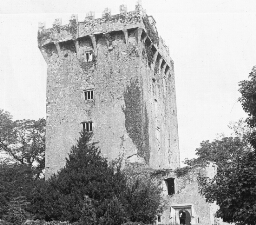 Blarney Castle, Ireland
Blarney Castle, Ireland
Find the city of Cork in Ireland. In what part of Ireland is it? Within 4 miles of Cork is the little village of Blarney. At Blarney is the famous castle of the same name. And in Blarney castle is a stone known the world round. It is the Blarney Stone. Every year thousands of tourists visit Blarney to see this stone. You know the story that goes about the stone. It is that anyone who kisses it will be gifted with a wonderful power of speech. He will become eloquent and be a leader in politics. Or he will be a teller of beautiful stories. Or he will be able to make his neighbors believe black is white. The power of this stone is related in verse as follows: There is a stone there, That whoever kisses, Oh, he never misses, To grow eloquent!" When the guide takes you over the castle he points out two stones. He does not know which is the real Blarney stone. You can take your choice. Most people prefer the one that requires the less climbing. Perhaps, after all, the Blarney Stone is only a myth. Perhaps people only imagine that there must be a Blarney Stone some where in Ireland, because the Irish have such glib tongues and beautiful speech. It is said that the best English spoken is in Dublin. Blarney Castle is a solid structure with few ornaments. It was built by a McCarthy in the fifteenth century. It is now slowly going into decay, but it tells of the fiery times in Ireland in the Middle Ages when castles were the forts of the land. Find the word "blarney" in the dictionary. What has it come to mean? Keystone ID: 2503 Note: All titles, descriptions, and location coordinates are from the original Keystone Slide documentation as supplied by the Keystone View Company. No text has been edited or changed. -
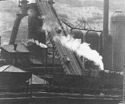 Blast Furnace, Pittsburgh, P.A.
Blast Furnace, Pittsburgh, P.A.
The United States leads all other countries in the production of iron ore. It produces over one-third of the ore of the world, or over 65,000,000 tons. Germany ranks second with over half this amount; the United Kingdom of Great Britain and Ireland ranks third with about one-fourth; and France ranks fourth with about one-fifth. Pittsburgh leads all other cities in the world in the manufacture of iron and steel. This view shows a section of one of the great Pittsburgh plants. The iron ore is drawn up the tracks on the steep incline in the center of the view. You see two of the cars now climbing the grade. The contents of theses cars are dropped into the big furnaces where the ore is heated to a great temperature by coke fires. This furnace is 85 feet high and 18 feet across its top. It is made of brick and cased with iron. The four drums to the right are huge stoves. These pump heated air into the furnace. You know fire will not burn without air. If cold air were turned into the furnace it would reduced the temperature. Engines drive this hot air into the furnace in great gusts or blasts. Hence the name, blast furnace. The pipe on the left side of the furnace is to carry off gases. The heat in this furnace must be as much as 2500° F. The manufacture of iron in the United States began first in Easton, Pa. Charcoal was used as a fuel in those days. Later it was learned that anthracite (n´ thrå-st) was a better fuel to smelt ore; and blast furnaces were located as near as possible to the hard coal fields. Still later it was learned that coke was even better than anthracite, for smelting purposes, and the iron business began to move from the hard coal fields in eastern Pennsylvania to the bituminous (b-t´ m-ns) fields in western Pennsylvania where it is now centered. Keystone ID: 6322 Note: All titles, descriptions, and location coordinates are from the original Keystone Slide documentation as supplied by the Keystone View Company. No text has been edited or changed. -
 Blowing the Alpine Horn, Grindelwald, Switzerland
Blowing the Alpine Horn, Grindelwald, Switzerland
The Grindelwald is a beautiful Swiss valley, and a favorite spot with tourists. It is bounded on the south by three high mountains. The lowest is over 10,000 feet high. One of these is the Wetterhorn, noted for its beauty. Between the three lie two large glaciers, the Upper and the Lower Grindelwald. Grindelwald village, with 4,000 population, lies in the valley. It is a summer and winter resort, and the starting point for trips to the many beautiful places about the valley. It is made up of buildings scattered over a wide area of ground. Hotels are plentiful, and most of the natives of the valley depend on the tourist trade for a living. Hotel servants, porters, guides, and shopkeepers all levy toll from the traveler. The man in the view, playing the Alpine horn, is not doing this because of his love of music. A carriage load of tourists are coming up the road, and he is expecting several silver coins to be loosed from their purses. He will stop playing when they come near, and ask them for "tips." The horn looks like a long tobacco pipe with a bowl too small for its length of stem. Tipping or feeing is a regular custom in Europe. If you are served in any way, the servant expects a fee. You tip your porter, your waiter at the table, your barber, your hotel keeper-everybody has his hand in for tips. When you leave your hotel, all the servants stand in a row at the door, awaiting their fees. The view shows beautifully a stretch of the glacier. The ice moves slowly down the valleys between the mountains. Farther down the valley it melts and forms a river of cold, clear water that goes dashing over rocks on its way to the lowlands. Keystone ID: 10703 Note: All titles, descriptions, and location coordinates are from the original Keystone Slide documentation as supplied by the Keystone View Company. No text has been edited or changed. -
 Box Canyon, Colorado
Box Canyon, Colorado
This view was taken within the city limits of Ouray, 400 miles southwest of Denver. The city itself is a great mining center, and a summer resort. You can understand why it should be so by looking at the scene. The city has an altitude of 7,700 feet, and above it tower mountains from 3,000 to 7,000 feet. One of its chief points of interest is here shown. Box Canyon (kn´ yn) get its name from its likeness to a box. It would be a very rough, irregular box, indeed; but after all, the walls are almost straight up and down. Formerly a river flowed on the surface where the canyon is now. This stream began cutting its bed through the layers of stone. Year after year it carved a trench downward through the solid rock. But the rock here does not lie in even layers, so that parts of them have broken off irregularly. This causes great gaps throughout the course of the gulch. From ledge to ledge bridges have been built and ladders have been laid to different levels. Here tourists like to stroll, especially in the heat of a summer's day. A canyon is a valley with steep sides. The word is Spanish, and means a tube or a cannon. Canyons develop fastest on great heights where the climate is fairly dry and where the rock lies horizontally. The height gives the streams a swift flow. Hence the cutting into the rock goes on more rapidly than if the streams move slowly. The dry climate prevents the washing in of the sides of the stream by rainfall. Most of the mountain streams in Colorado are fed by melting snow. The water flows swiftly, staying in one channel year after year so that a gulch into the solid rock is cut after a time. What is a canyon? Where is the Grand Canyon of the Colorado? Explain how a canyon is formed. Keystone ID: 8008 Note: All titles, descriptions, and location coordinates are from the original Keystone Slide documentation as supplied by the Keystone View Company. No text has been edited or changed. -
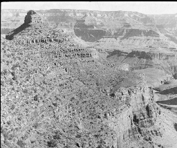 Bright Angel Trail, Grand Canyon of the Colorado, Arizona
Bright Angel Trail, Grand Canyon of the Colorado, Arizona
The tourist who visits the Grand Canyon of the Colorado would want first to see the canyon (kn´ yn) from its rim. If he could get a bird's eye view of it, it would be still better. He would see 400 miles of canyon zigzagging across an almost treeless plain. And over a mile below, at the bottom of the gorge, he would see the Colorado River. The River looks like a silver thread winding its way through the many-colored rocks. He might spend days on the rim of the canyon, visiting various points of interest-Grand View, Shoshone Point, Yuma Point, Hermit Rim, Sentinel Point, and many others. Then the tourist would want to visit the depths of the canyon. The view here shows one of the trails to the bottom. This is Bright Angel Trail. There are three other paths leading down into the canyon. You can imagine that these trails are steep and rugged, when you remember that it is over a mile from the rim of the canyon to its bottom, where the Colorado flows. The other three trails are Hermit Trail, Bass Trail, and Grand View. The journey is made on the backs of mules. By way of the Bright Angel Trail the trip is about 7 miles. It takes 3 hours to go down and about 3½ hours to make the return journey. At some points on the trail, the riders can look over the edge of the precipice and see straight down a distance of several thousands of feet. It is about 4,000 feet high from the lowest place you see, to the plateau level shown in the background where the earth and sky seem to meet. The Colorado lies 1,000 feet below, the lowest point in the scene. That is, the distance from the bottom of the canyon to the top at this point is about 5,000 feet. Keystone ID: 13600 Note: All titles, descriptions, and location coordinates are from the original Keystone Slide documentation as supplied by the Keystone View Company. No text has been edited or changed. -
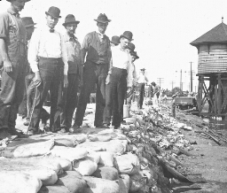 Building Dikes Along the Mississippi to Protect East St. Louis, Illinois, from Flood
Building Dikes Along the Mississippi to Protect East St. Louis, Illinois, from Flood
Floods are the terror of people who live in river valleys or along low sea shores. The inhabitants of such places protect themselves from overflows by building walls of various kinds. You recall that the Hollanders have reclaimed most of their land from the sea. This they have done by building dikes of earth and stone so that most of their little country is below sea level. In our own country, many places along the seashore are severely damaged each year by the water driven in from the ocean by high winds. One of the worst floods of this kind occurred at Galveston in 1900. A storm swept from the southeast over the gulf of Mexico. In Galveston many lives were lost and much damage to property was done. To protect themselves against a similar occurrence, the city has built a concrete seawall 17 feet high and more than 3 miles long. But by far the most damaging floods we have are caused by our rivers. Each spring we have a heavy rainfall, usually extending throughout the country. The small streams are swollen into torrents. These, in turn, empty into the rivers which spread out over the lowlands. Along the Ohio and the Mississippi Rivers a great deal of property is ruined every year by overflows. This view shows the common way of keeping the waters from spreading. The bank is made of bags of sand. These banks may be miles in length. When the water is at its height, men patrol these levees day and night to see that the water does not break through them. Sometimes, in spite of their watchfulness, the river cuts through, and then it is a race for life. One of our great national problems is to prevent river floods. Keystone ID: 20118 Note: All titles, descriptions, and location coordinates are from the original Keystone Slide documentation as supplied by the Keystone View Company. No text has been edited or changed. -
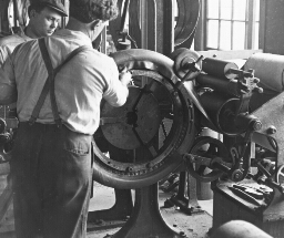 Building up Automobile Tires, Akron, Ohio
Building up Automobile Tires, Akron, Ohio
In the crude rubber received at the factory are sticks, dirt, bits of leaves, and beetles. These are removed by grinding the rubber in a water bath. The particles of dirt are thus washed away. The rubber is now pure enough for the first process of manufacture. The next step is to mix the rubber with the chemicals. This is called compounding. In the factory here shown four or five hundred different chemicals are used to compound with rubber. Some of these are to give strength and toughness, others to give color to the rubber. It is possible to make rubber that is tougher than steel. The rubber is now ready for manufacturing purposes. What next happens to it depends on the uses to which it is to be put. For example, if it is to be made into the bandages that dentists stretch across the mouths of patients, it must be rolled very thin. This process is called sheeting. One of the greatest uses for rubber today is in the manufacture of automobile tires. You see here an automobile tire being built up. The framework of a tire is its body of fabric or tough cloth. On an iron core, the shape of the tire, this fabric is first wound several thicknesses. This is what the men here are doing. It is a work that demands care and skill. To become an expert workman in this department a man must have a steady hand, deft fingers, a clear eye, and good judgement. There is another way of building up tires. This is by using two crossed layers of heavy cords instead of fabric to wrap about the iron core. These cords have been filled with a rubber solution under high pressure. They are laid on the core by a machine. A tire so built up is called a Silvertown. Keystone ID: 22058 Note: All titles, descriptions, and location coordinates are from the original Keystone Slide documentation as supplied by the Keystone View Company. No text has been edited or changed. -
 Burbank, the Plant Wizard, Santa Rosa, Cal.
Burbank, the Plant Wizard, Santa Rosa, Cal.
In 1849 in Lancaster, Mass., Luther Burbank was born. He was not a husky lad, so he could not "follow the sea" as so many New England boys of his day decided to do. He stayed at home instead and tilled a rocky farm. He early showed a real insight into pant life. He felt that farmers did not understand the first principles of dealing scientifically with plants. One of his first attempts to improve farming methods was in raising corn. The earlier that cooking corn or "roasting ears" are put on the market, the better the price. Burbank sprouted hi seeds early in leaf mold. His corn came up in a few hours. He forced its growth, and amazed everybody by marketing corn weeks ahead of other farmers. His next adventure was with potatoes. For four years he experimented with varieties of potatoes until he had a kind that was big, smooth, and large producers. Burbank's potatoes were soon known from coast to coast. They are still one of our popular varieties. From his potatoes he secured money enough to go to southern California. Here he has since worked. By crossing different varieties he was able to produce newer and better ones. He has developed the white blackberry, the ever-bearing rhubarb, the crimson poppy, and the stoneless plum. One of his most widely known plants is the spineless cactus. Cacti grow wild over the half desert country of the southwest, where there is not moisture enough to support grass. Animals like the flavor of the plant, but could not eat it because of the sharp spines on the leaves. Burbank experimented till he produced a variety without spines. Now great stretches of land that were once useless will produce rich pastures. Keystone ID: 16746 Note: All titles, descriptions, and location coordinates are from the original Keystone Slide documentation as supplied by the Keystone View Company. No text has been edited or changed.
Showing 1-50 of 404 records.